Charting the Course to Success: Maps and Mapping
In my post-university, GIS-related job I’m currently georeferencing historical maps from the state library; so, it was very useful for me to have done this in the Maps and Mapping course (ASIA2018/ASIA6018) last year! The education I received not only set me up excellently to process data for GIS analysis, but also to go the step further and work critically and creatively. I've had a great year working in the GIS industry! – William Holmes a Court
Maps are an often-underutilised resource and mapping (and GIS). They are often seen as involving skills too complex for some of us to try and attempt. For former ANU student William Holmes a Court, all this changed once he followed the signs to the Maps and Mapping (ASIA2018/ASIA6018) course offered at the ANU School of Culture, History & Language, which sits within the ANU College of Asia and the Pacific.
Whether or not you’re clear about which direction you’re headed in, maps are fascinating for varied reasons. They can be simply fascinating in their own right, as evidenced by the many map collectors around the world. Maps are also a fundamental tool across a wide variety of disciplines and careers. There are also many prospects to explore the world of maps as a window into our Asia-Pacific past.
Maps and the process of mapping have long been integral to how people interact with the world.
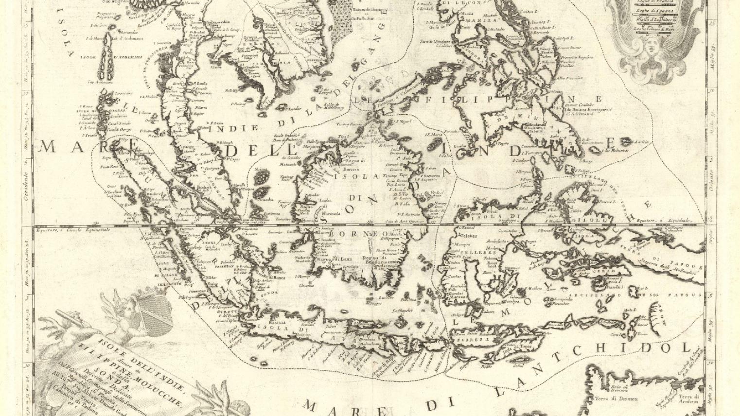
The pursuit of spice profits drove European expansion into Southeast Asia. Maps and navigational charts were pivotal in these trade wars.
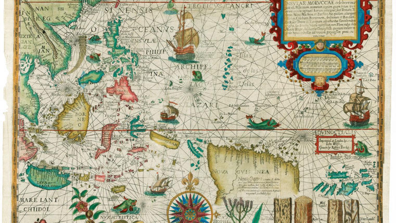
Portuguese early dominance relied on closely guarded navigational knowledge and charts. Dutch agent Linschoten's covert efforts collected intelligence, emphasizing maps' role in espionage. This was an age when sea captains would rather destroy charts than have them fall into enemy hands, and passing data to a foreigner was considered a treasonable offence punishable by death.
Collaborating with cartographer Plancius, Linschoten produced detailed maps such as "Insulae Moluccae," vital for navigation and strategy. These maps enabled Dutch trade expansion, marking a turning point in maritime dominance in Southeast Asia.
The art and science of mapmaking is integral to research as not only an investigative tool, but as a means of presenting research results. They are treasure troves of stories about a region at different periods of time. They are also excellent mediums to communicate data and ideas while also offering unique insight into past cultures and politics.
Those who have studied maps would agree that if "a picture is worth a thousand words" a map is perhaps worth two thousand! Maps are a key tool for any budding researcher—both as a means to conduct research as well as present research results.
In our modern digital world, an appreciation for geospatial data, how to access, manipulate, and assess it, is an increasingly invaluable skill.
While paper wayfinding maps have given way to online maps and computer-generated directions, thematic maps that show geographic aspects of phenomena are now more abundant than ever. Maps have likewise become increasingly important in the humanities and social sciences.
Destination ASIA2018
The Maps and Mapping in Asia and the Pacific undergraduate course, convened by Dr Shimona Kealy, investigates maps both in the contexts of social sciences and the humanities. The course provides insight into the social life of maps as well as the techniques and tools needed to make your own maps.
Explore what a map is, how they influence our society, and what they can tell us about the past—with a particular focus on the Asia and Pacific regions. During weekly lab periods, students learn to collect spatial data using GPS, access freely available spatial datasets, and use this spatial data and geographic information system (GIS) software to create maps. Students also perform an independent mapping project and create a 'StoryMap' to present their results.
Gain experience with accessing the wealth of mapping resources available for using and researching modern and historical maps of Asia and the Pacific. Explore the techniques and tools needed to make your own maps in Google Earth and ArcGIS.
No matter what discipline you’re associated with or which roadmap you intend to follow, the skills and knowledge gained in this course can be applied to a wide range of disciplines, hobbies, and industries including geography, archaeology, history, heritage, environment, and transport.
Find your bearings with this program and learn to navigate Asia and the Pacific like a pro. To know more, click here.